GTA 6 Map: How Big Is Leonida, Really?
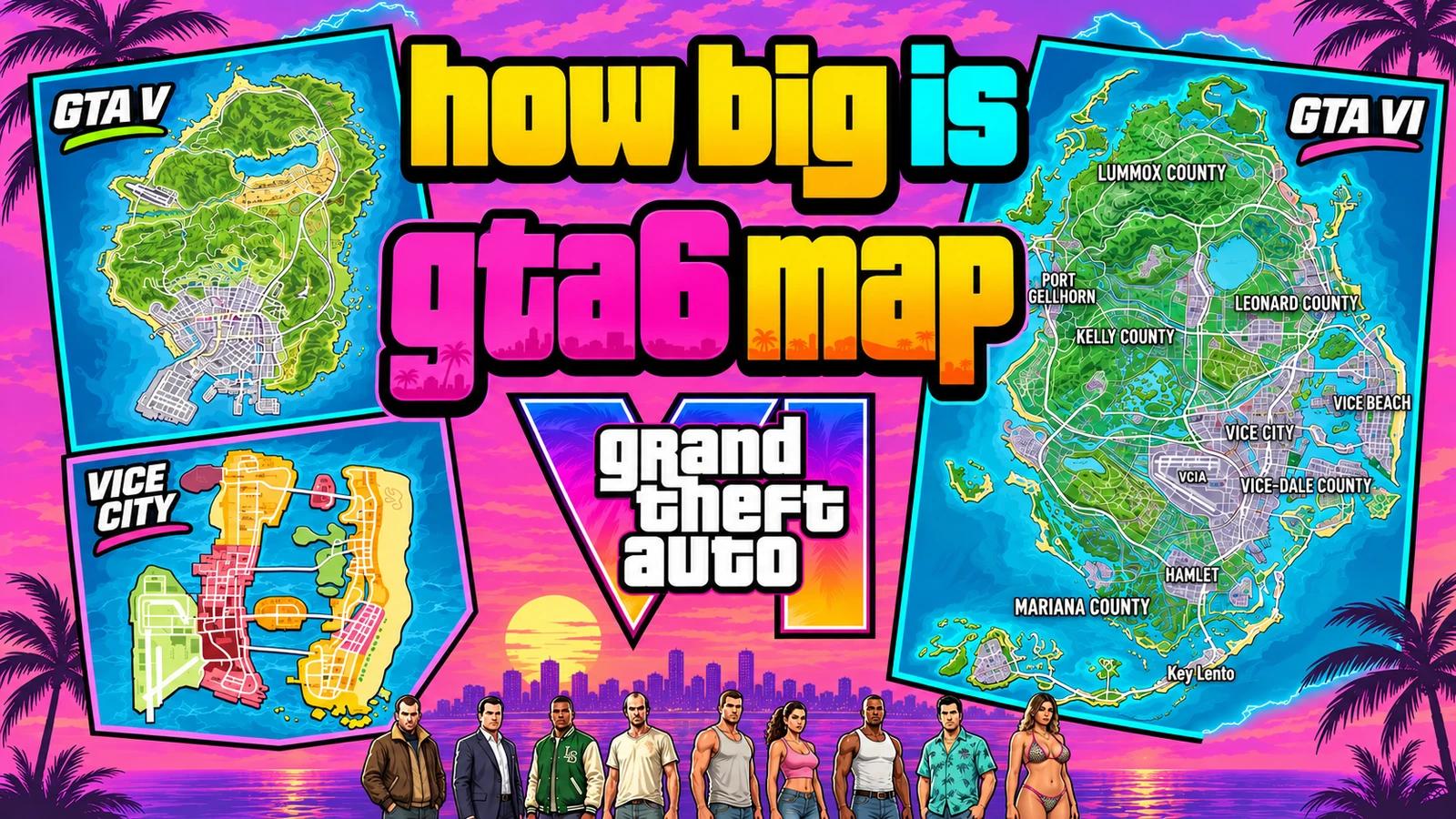
Checked 22 November 2026. GTA 6 reporting and gameplay below were published on 20–21 November (UTC), after the 19 November release. Rockstar’s original launch-day map is the primary map source. Older games’ maps and background references are clearly labelled archival. Map labels and videos can reveal locations and early missions; the long walkthrough includes broader story spoilers.
How big is the GTA 6 map? Big enough that looking only at Vice City misses the point. Leonida stretches from a busy urban bay to wetlands, inland settlements, mountain country and a long southern island chain. It is the difference between taking a city break and deciding, very unwisely, that you can squeeze an entire state into one road trip.
The useful answer needs three things: the real map, comparisons that use the same definition of size, and actual journeys through the released game. This guide brings those together. You can zoom into Rockstar’s poster below, find thirty indexed places, compare every requested GTA setting, and examine what a ten-minute highway crossing does—and does not—tell us.
The cover is an AI-assisted editorial collage of the three games’ maps and stylised characters, with exaggerated character proportions. It is sized for the thumbnail rather than to a common geographic scale. The explorable map and regional close-ups inside the article come from Rockstar’s original map, not generated artwork.
How big is the GTA 6 map after release?
The short answer: GTA 6’s setting is the wider state of Leonida, not just Vice City. A post-launch map guide updated 20 November repeats the reported comparison of roughly twice GTA 5’s map. That is a broad comparison, not a published, consistently measured land-area total in square kilometres. We have not verified a released-game measurement that settles that number.
Rockstar’s poster is now a much stronger starting point than a pre-release reconstruction. It shows the connected road network and the coastline you actually need to understand. It does not identify a single polygon labelled ‘playable area’, explain which surrounding water belongs in a size total, or supply a road graph from which the mathematically longest route can be calculated.
State versus city: compare Leonida with GTA 5’s full main map; compare Vice City’s urban footprint with Los Santos separately.
Land versus water: do not divide a land-only figure by another game’s land-and-water figure.
Area versus journey: square kilometres, kilometres of road and minutes behind the wheel answer different questions.
Published test versus record: one documented crossing is useful evidence; it is not automatically the fastest route or the farthest pair of accessible points.
Post-release map reporting: GTAside, 20 November. Primary artwork: Rockstar’s GTA VI Media page.
Explore the official GTA 6 map in fullscreen
Official map · 30 indexed places
Drag to pan. Scroll or pinch to zoom. Keyboard: arrows move, +/− zoom, Home resets.
Start with the six-region layer for orientation. Search a name to find it across the whole index, or switch to cities, transport locations and natural landmarks. Selecting a place centres the map and zooms in. Hide the added pins whenever you want to study the original poster without our overlay.
The full-resolution display copy preserves the original 5,775 × 7,900 dimensions. The print download remains linked directly to Rockstar. Our numbered pins are approximate positions read from the poster, not extracted game coordinates; they do not claim to mark every mission, secret, collectible, shop or activity. The original printed names and symbols remain in the image whether our pins are shown or hidden.
How to read the road legend, grid and map index
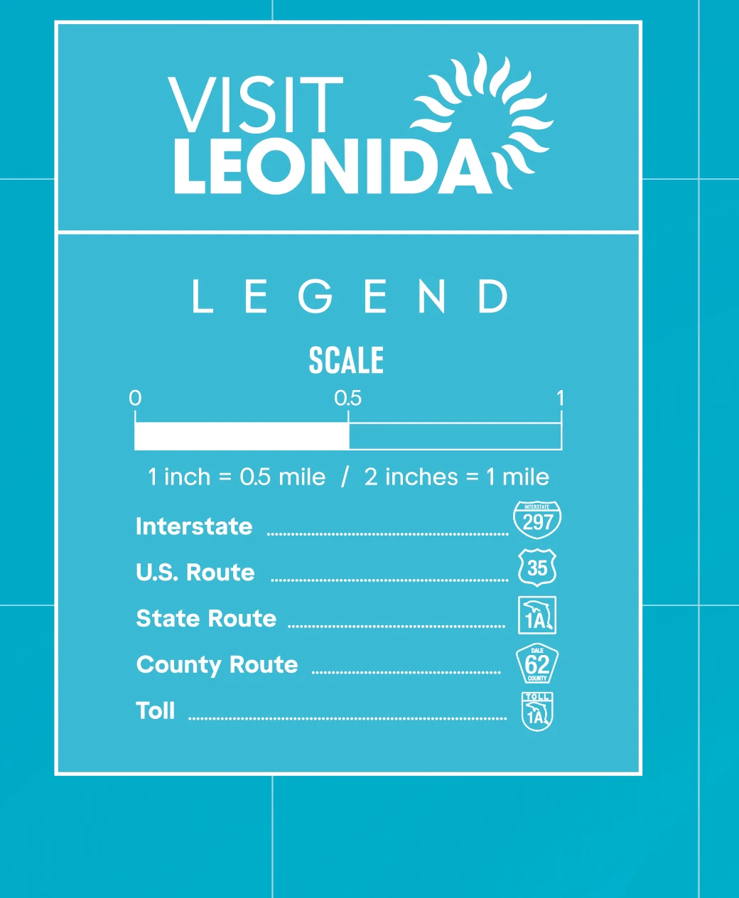
Original map detail © Rockstar Games. This close-up retains the printed legend; it has been cropped and re-encoded for the web.
The poster uses letters A–M down the sides and numbers 1–9 across the top. Those are lookup cells, not distances. Our index gives approximate cells so you can return to an area quickly. A city name can span more than one cell, and an index pin should never be treated as the precise entrance to a building.
Read the sign shapes as well as the lines. The legend distinguishes interstate, U.S., state, county and toll routes. Shields such as 297 and 404 help you follow major corridors; the 1A corridor provides an obvious way to trace the southern island chain. A route number is not a speed limit, and a line through a region is not proof that every nearby surface is drivable.
The printed scale says one inch represents half a mile. That physical relationship belongs to the intended print format. A responsive image on a phone, a zoomed browser tab or a resized screenshot no longer has that physical size. Measuring the display with a ruler will not give you a reliable in-game distance. A rigorous world-area calculation needs a separate calibration against the game.
For another post-release transcription of the poster’s names and five counties, see SixStarsWanted’s map index, read 20 November. We use our own smaller, hand-positioned index below rather than presenting a third-party collectible database as verified game data.
GTA 6 map index: thirty places to find
Vice City — approximately G7. Region overview.
Leonida Keys — approximately L5. Region overview.
Grassrivers — approximately I5. Region overview.
Port Gellhorn — approximately E3. Region overview.
Ambrosia — approximately E6. Region overview.
Mount Kalaga National Park — approximately C5. Region overview.
Bonanza — approximately B5. City, district or settlement.
Grayson — approximately C4. City, district or settlement.
Millport — approximately C7. City, district or settlement.
Waning Sands — approximately E7. City, district or settlement.
Belville — approximately F7. City, district or settlement.
Capri — approximately G3. City, district or settlement.
Hamlet — approximately J6. City, district or settlement.
Watson Bay — approximately J4. City, district or settlement.
Key Lento — approximately L6. City, district or settlement.
Southwind — approximately L3. City, district or settlement.
Vice Beach — approximately G8. City, district or settlement.
Little Cuba — approximately G7. City, district or settlement.
Downtown — approximately G7. City, district or settlement.
Ocean Beach — approximately G8. City, district or settlement.
Vice City International Airport (VCIA) — approximately H6. Transport landmark.
Mile Zero Air Station — approximately L3. Transport landmark.
Port Vice City — approximately H8. Transport landmark.
Draper Island — approximately D3. Transport landmark.
Lake Leonida — approximately E6. Natural or built landmark.
Breakwater Quarry — approximately H4. Natural or built landmark.
Buckskin Swamp — approximately G5. Natural or built landmark.
Leaf Links — approximately F8. Natural or built landmark.
Pelican Valley — approximately J5. Natural or built landmark.
Richard Barbeque State Park — approximately D7. Natural or built landmark.
Leonida’s six regions and five counties are different things
The poster prints five counties: Lummox, Leonard, Kelly, Vice-Dale and Mariana. The six familiar region names describe a different way of navigating the setting. Mixing those two lists produces confusing claims such as treating every featured region as a separate county. Ambrosia, for example, is a settlement printed within Leonard County on this poster.
Vice City and Vice Beach: read the whole bay
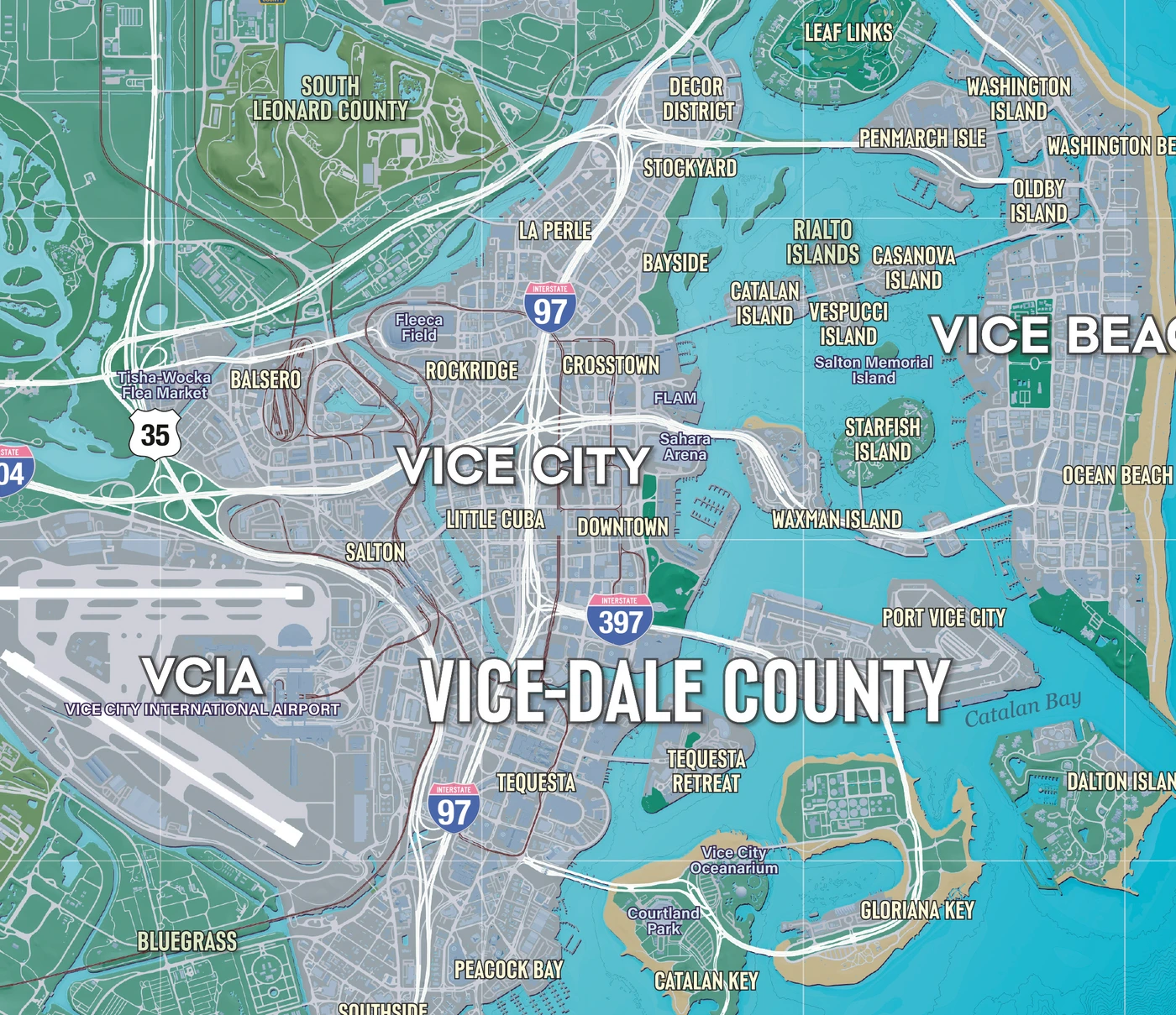
Rockstar map close-up. The city detail is useful for comparing street layout, not for assuming a measured urban-area ratio.
Treat this as a network rather than a blob of grey land. The urban streets, barrier-island beach side, bay crossings, airport approaches and port corridors offer different types of movement. When you compare cities, decide whether you are counting only continuous city blocks or also the huge infrastructure spaces around them. That choice changes the result before you have measured a single pixel.
Leonida Keys: bridges make the distance matter
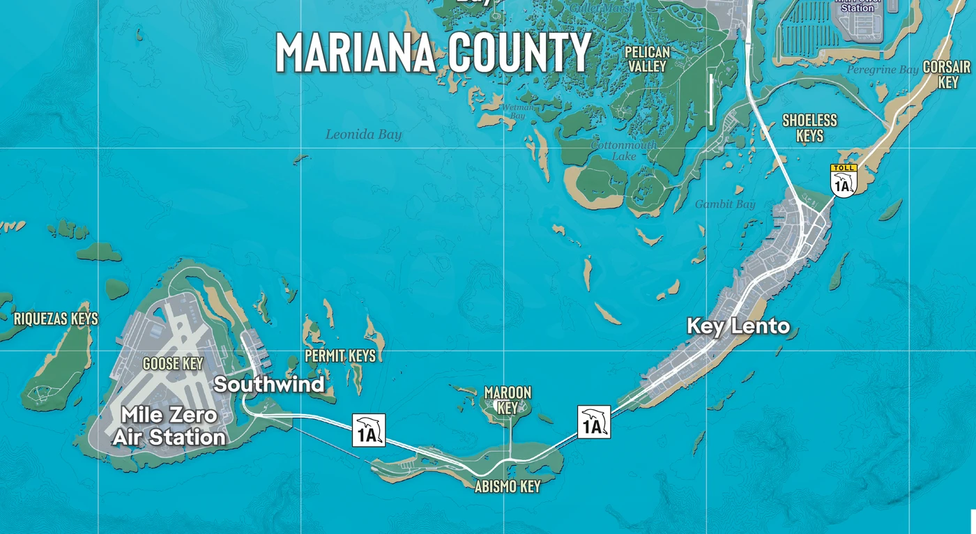
Rockstar map close-up. The southern island chain makes a good example of road distance differing from straight-line distance.
A narrow island chain can occupy less land than a broad mainland region while still producing a memorable drive. The important unit is connectivity: how many ways can you leave an island, where do roads reconnect, and how much detour does a blocked approach force? That is why the Keys belong in a driving comparison even when a simple area chart barely communicates their shape.
Grassrivers: a road map cannot describe every journey
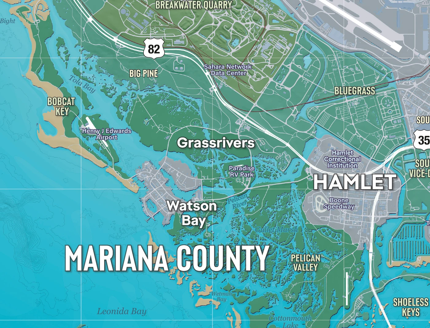
Rockstar map close-up. Wetland water and road-accessible land should be counted separately.
Wetlands are a useful reminder that ‘explorable’ and ‘drivable’ are different categories. A route can look short from above and still require a road detour; a boat journey can tell a different story again. For a fair comparison, keep the travel mode fixed instead of giving one game credit for a boat shortcut and forcing its rival to stay on asphalt.
Released-game footage: GTA Series Videos’ Swamped walkthrough, published 20 November. This is a mission walkthrough with spoilers, not an area survey or timed end-to-end benchmark.
Port Gellhorn: another urban centre changes the network
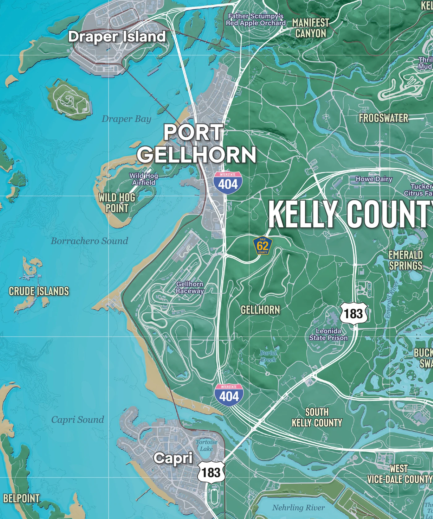
Rockstar map close-up. A second urban centre is a useful comparison point when judging how destinations are distributed.
For world design, the interesting question is how often a long trip offers another reason to stop. A second cluster of streets and infrastructure creates a different mental map from a single metropolis with a distant endpoint. Look at the western coast as a destination network, then ask how its connections affect a round trip rather than only a sprint between two extremes.
Ambrosia and Lake Leonida: separate water from land
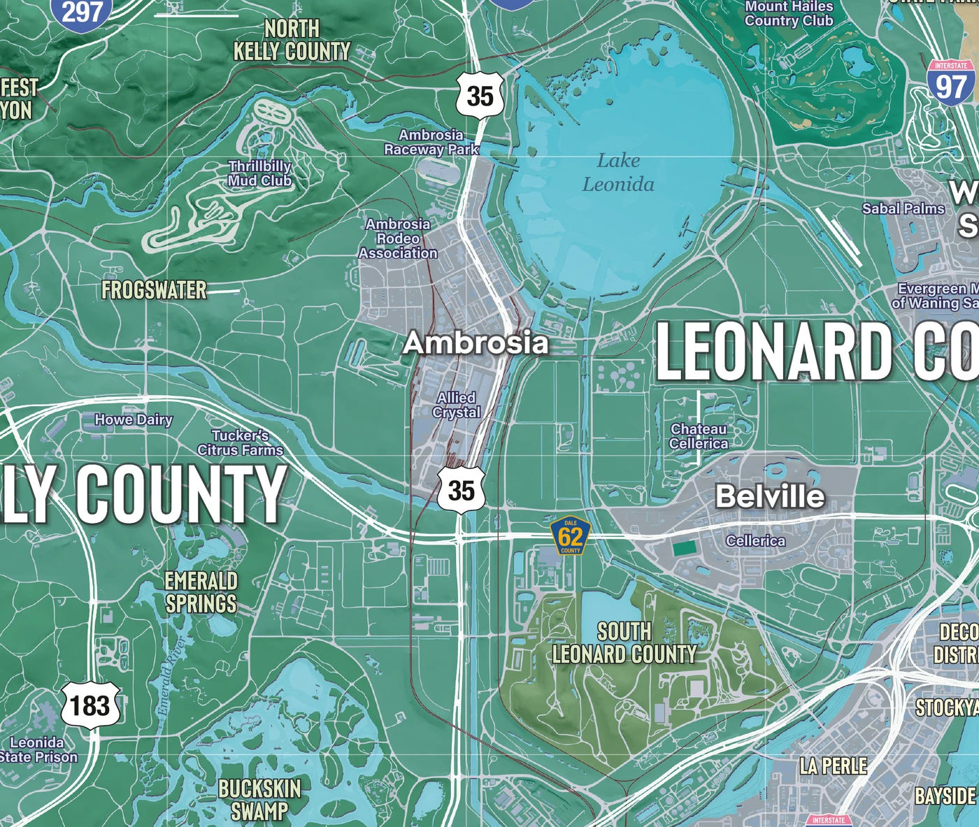
Rockstar map close-up. The lake is a visible example of why a rectangular map frame overstates land area.
Trace the routes around a large lake and you immediately see the problem with a bounding-box statistic. A rectangle can contain roads, towns, water and empty corners in one neat total. That total may be useful for image dimensions, but it is not a measurement of playable ground. The same mistake can make two honest-looking comparison charts disagree dramatically.
Mount Kalaga: terrain adds time without adding city blocks
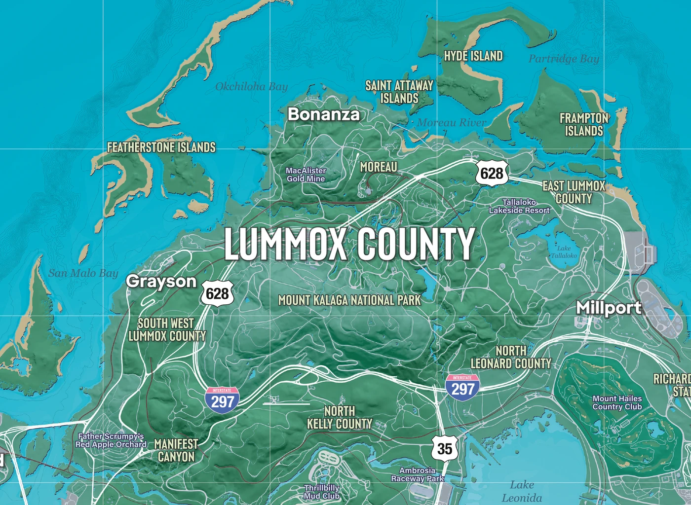
Rockstar map close-up. Contours and winding approaches make northern terrain a different comparison from the urban grid.
A mountain road is a good test of what your chosen statistic leaves out. Elevation, bends and access points can make a geographically compact section feel substantial. Conversely, a long, direct highway can make a much larger region pass quickly. Neither experience makes the map ‘fake big’; it means the experience depends on geometry and movement as well as total area.
GTA 6 map vs GTA 5: Leonida, Los Santos and city area
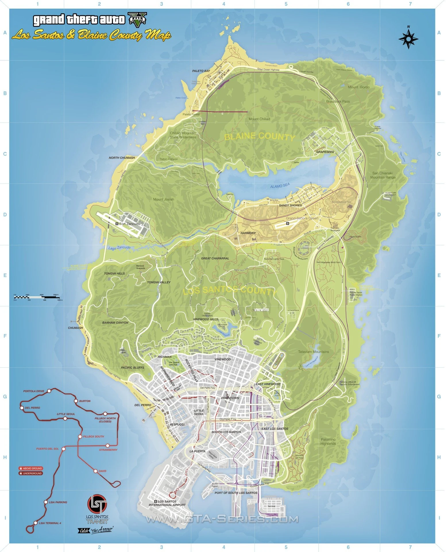
Archival comparison map: GTA V’s official poster via GTABase. Map artwork © Rockstar Games. These posters are shown at different display sizes, not at a common geographic scale.
GTA 5’s main map combines Los Santos with Blaine County and their surrounding terrain. The equivalent GTA 6 comparison is the wider Leonida map. Comparing all of Leonida against only Downtown Los Santos would flatter the new game with a mismatched baseline. Equally, counting every patch of offshore water in one game while excluding it in the other would make the headline a boundary-selection contest.
For a city-only comparison, draw a declared boundary around continuous urban development in each game. Say whether airport runways, port facilities, golf courses, parks and separate beach islands count. Then measure road length, intersection density and destinations inside those boundaries. Those are more useful urban questions than quietly recycling a whole-state ratio as a claim about city streets.
Our map-reading comparison: the important change to inspect is the distribution of destinations around Leonida’s bay, western coast, inland routes and island chain. This is a reading of the published layouts, not a measured claim that Vice City has a particular multiple of Los Santos’s buildings, residents or accessible interiors.
Keep the GTA 5 baseline consistent: North Yankton is a separate story location, and GTA Online’s Cayo Perico is a separate island. Adding either to a Los Santos road-trip figure changes the question. See GTABase’s GTA 5 location guide for how those locations are distinguished.
Post-release viewing: theRadBrad’s Part 3, published 20 November. Use the street-level footage to assess the feel of travel; this story playthrough is not a controlled GTA 5-versus-GTA 6 benchmark.
GTA 6 map vs GTA 4: dense city streets versus a state
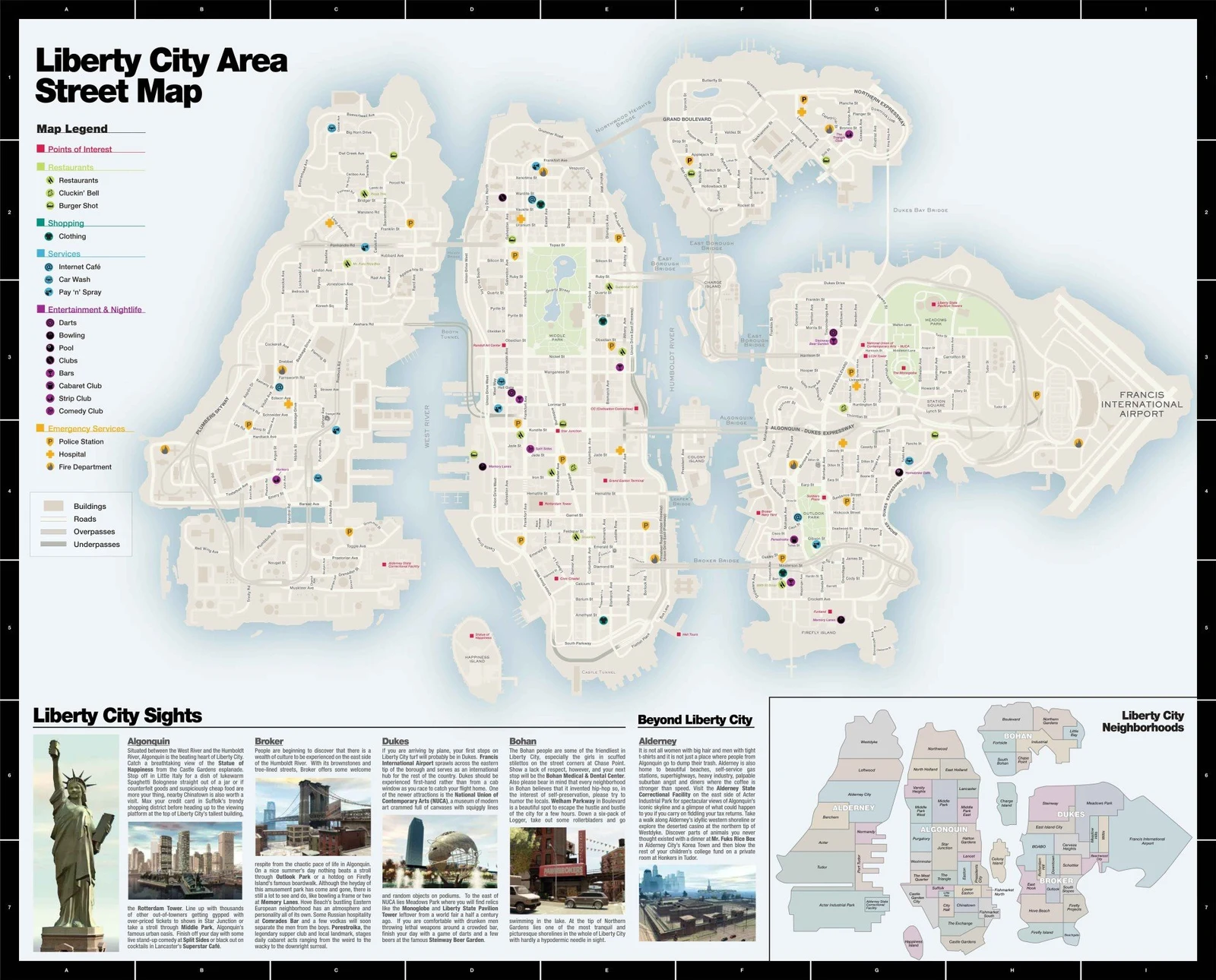
Archival comparison map: GTA IV’s official poster via GTABase. Map artwork © Rockstar Games. These posters are shown at different display sizes, not at a common geographic scale.
GTA IV’s Liberty City and Alderney are a particularly useful counterexample to ‘more square kilometres means a better world’. Its boroughs, bridges and built-up streets concentrate the comparison around urban movement. Leonida invites a broader regional journey. One can offer a tighter city drive while the other offers more changes of setting; those are different strengths.
If you want to compare the two honestly, choose an urban test in both: a fixed number of kilometres on city streets, the same traffic-rule policy, and equivalent vehicle performance. Comparing GTA IV’s junction-heavy route with a GTA 6 freeway sprint mostly measures the kind of road selected. For geographic background, see GTABase’s Liberty City and Alderney guide.
GTA 6 map vs GTA 3: three islands, different design priorities
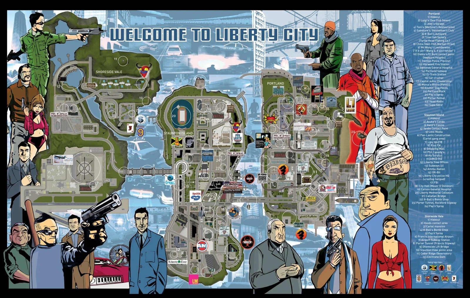
Archival comparison map: GTA III’s original map poster via GTABase. Map artwork © Rockstar Games. These posters are shown at different display sizes, not at a common geographic scale.
GTA III’s Portland, Staunton Island and Shoreside Vale make the geography easy to remember as distinct areas connected by key links. That compact structure is valuable in its own right. A route can feel significant because a bridge is a meaningful transition, not because the landscape beneath it contributes a huge number to an area total.
For Leonida, look for the same legibility at a larger regional scale: which links define your journey, which districts feel distinct, and can you remember where a road leads without staring at the minimap? That is an original design comparison, not a claim that two decades of hardware improvements can be reduced to one percentage.
GTA 6 map vs Vice City: the 2002 map is not the 2026 city
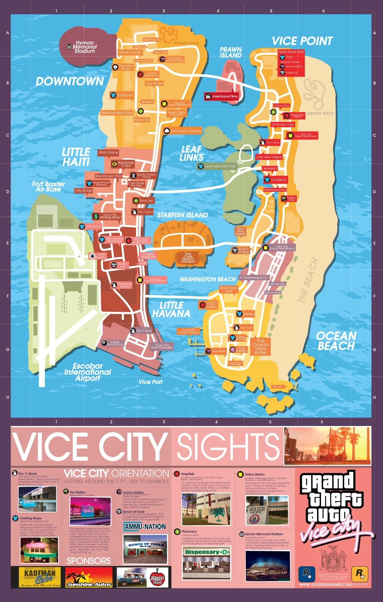
Archival comparison map: Vice City’s original map poster via GTABase. Map artwork © Rockstar Games. These posters are shown at different display sizes, not at a common geographic scale.
The 2002 Vice City layout has two main islands and smaller bay locations. GTA 6 revisits the name and the Florida-inspired setting in a different, much wider map. Familiar place names are useful nostalgia, but they are not evidence that the old road grid has simply been enlarged like an image in a photo editor.
The best comparison is a tour of relationships: beach versus mainland, waterfront versus business streets, bridges versus local roads. Look for what has been reimagined, then compare the surrounding state separately. A resized side-by-side poster can show visual differences, but it cannot establish an accurate ‘fits inside’ ratio without matching the scales. Background: GTABase’s Vice City map guide.
GTA 6 map vs San Andreas: why three cities still matter
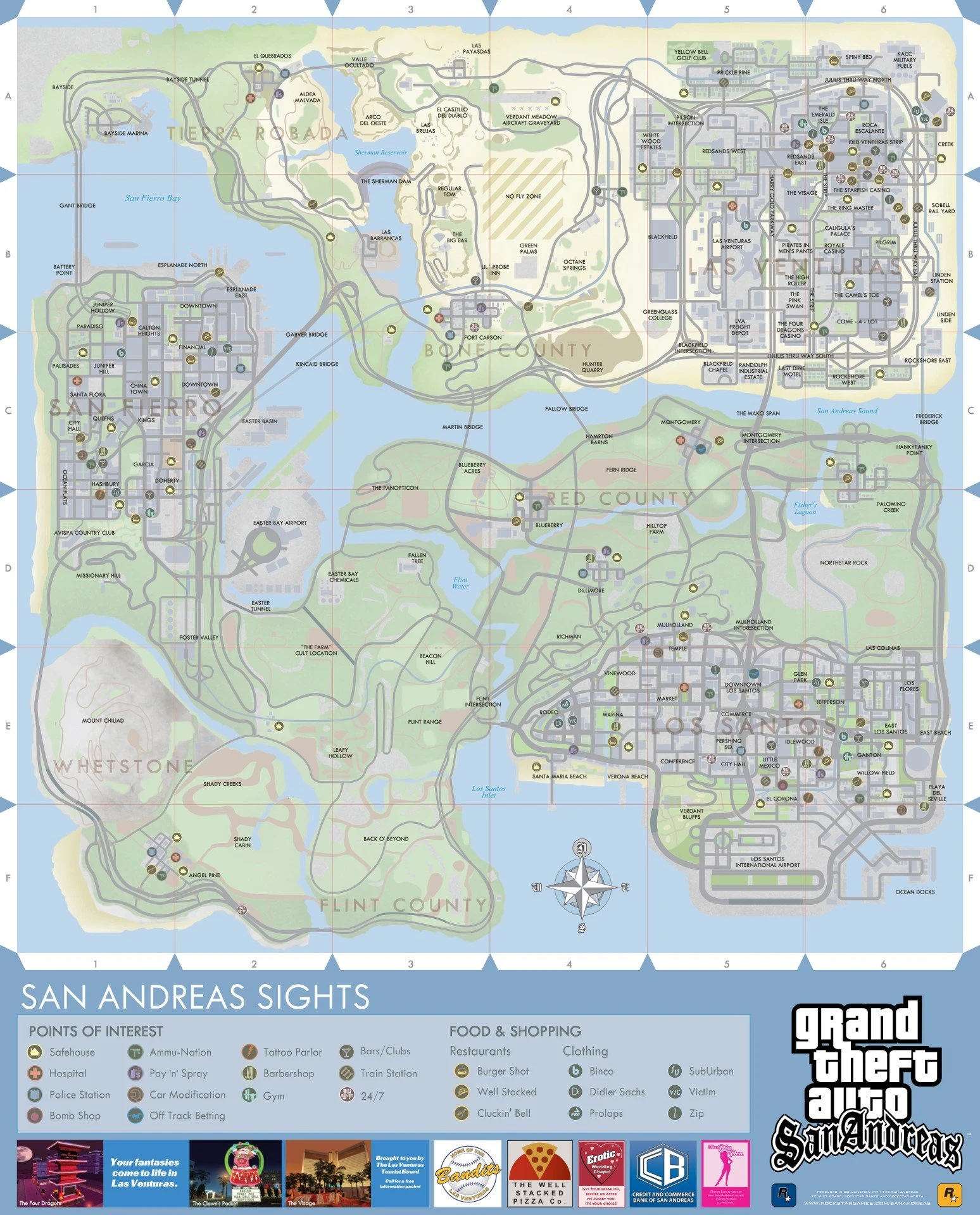
Archival comparison map: San Andreas’s original map poster via GTABase. Map artwork © Rockstar Games. These posters are shown at different display sizes, not at a common geographic scale.
San Andreas builds its journey around Los Santos, San Fierro and Las Venturas, with countryside and desert between them. That arrangement gives players memorable changes of identity. The interesting question for Leonida is not merely whether its land total is larger; it is whether its destinations make you want to cross the map again after the first novelty drive.
Compare the rhythm of a multi-stop trip: leaving a city, travelling through a contrasting region, then arriving somewhere with a different street pattern and purpose. A smaller world can communicate a surprising amount of distance through those transitions. That is why San Andreas remains relevant to this discussion even when an area chart puts it below a newer game. See GTABase’s cities and countryside guide.
GTA map-size comparison in square kilometres: the historical baseline
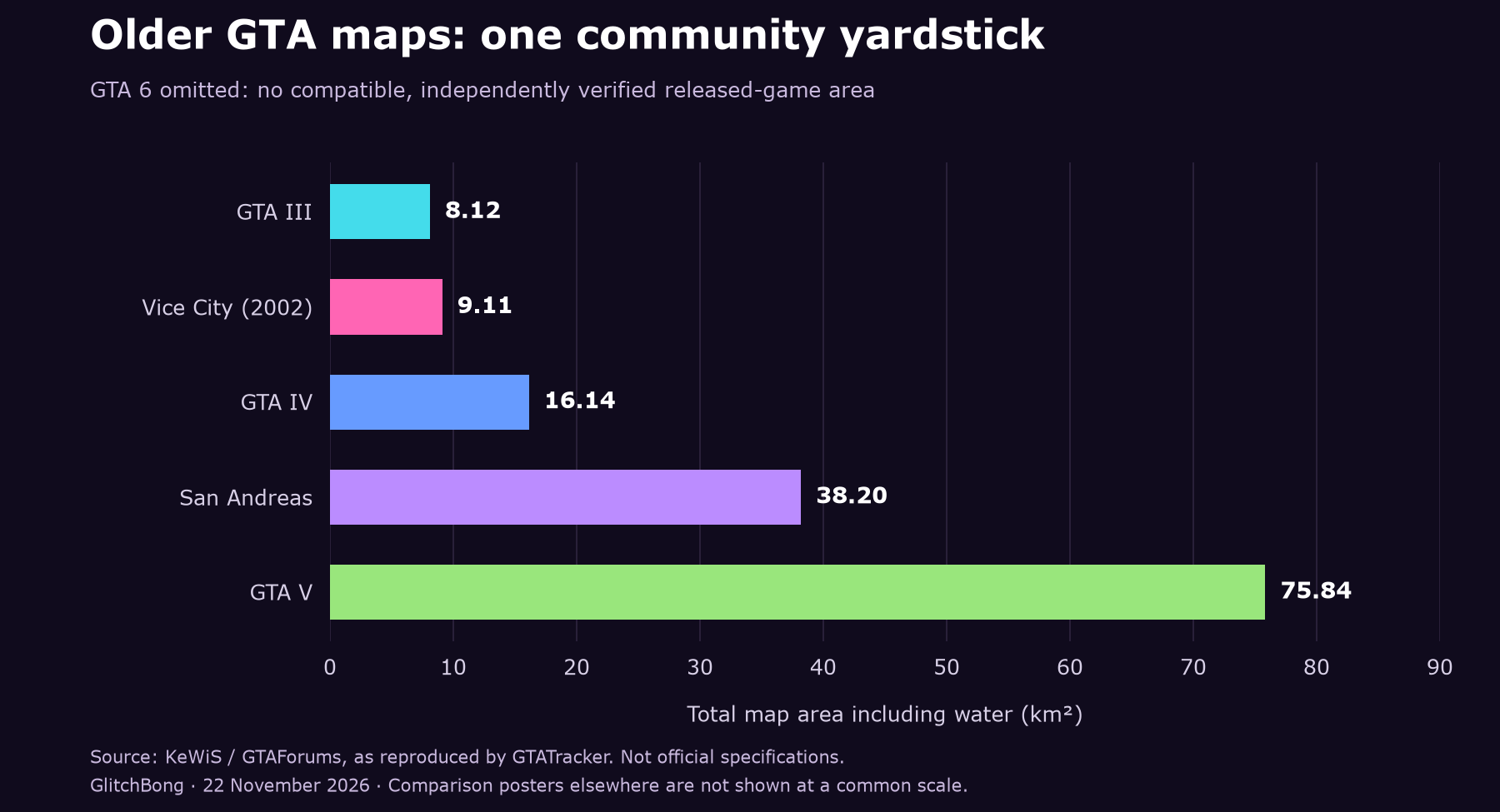
Original GlitchBong chart, created 22 November 2026. Historical community totals, including water: GTA III 8.12 km²; Vice City 9.11 km²; GTA IV 16.14 km²; San Andreas 38.20 km²; GTA V 75.84 km². These are not official specifications. GTATracker’s methodology page reproduces and discusses the KeWiS GTAForums comparison; access to the original forum thread may be restricted.
We deliberately leave GTA 6 out of the measured bars. Multiplying an old total by a reported ‘about twice’ ratio would create a derived scenario, not a fresh measurement of Leonida. The result might look beautifully precise to two decimal places while resting on an undefined boundary. Keeping the uncertainty visible is more informative than decorating an estimate with false precision.
To update this chart properly, a mapper would need to publish the coordinate scale, the accessible boundary, the water policy and the polygons used for every game. Ideally the measurements would be reproducible. Until that matched dataset exists, the historical chart is a baseline for the older entries rather than a definitive ranking of every world in this article.
How long does it take to drive across GTA 6?
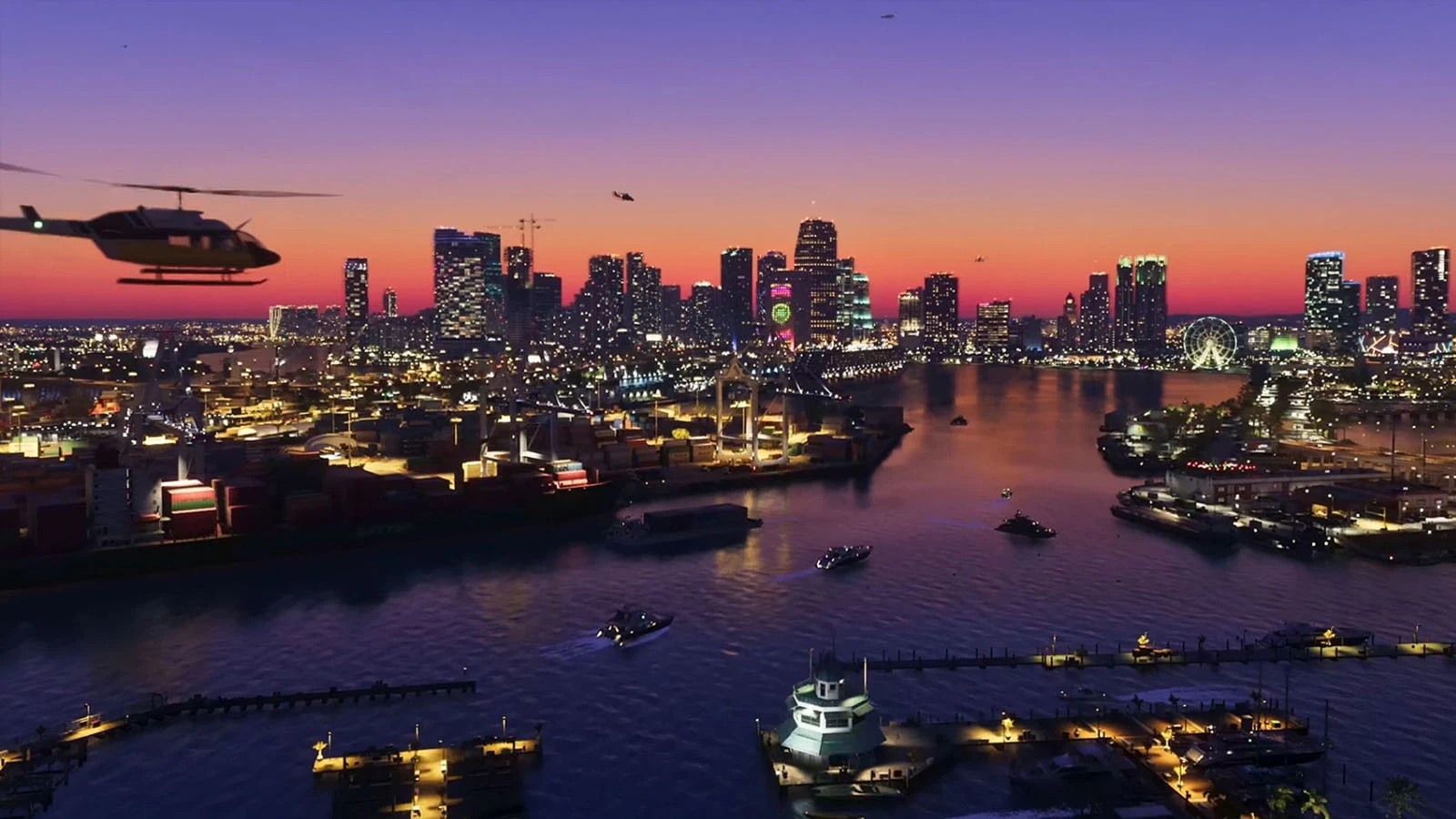
Post-release image: Rockstar Games via GamingBible’s 20 November road-trip report.
GamingBible reported roughly ten real-world minutes from Key Lento to Bonanza in an upgraded Stainer, letting the game’s GPS choose the quick route and using the freeway. That is an identifiable journey with a named vehicle and route policy. It is not a claim that every possible crossing, every starting point or every vehicle will take ten minutes.
For a useful retest, write down the exact start and finish, car and upgrades, story state, traffic conditions, weather and whether the clock includes crashes, menus or photo stops. Record the route continuously. Then repeat it. A clean run and an eventful first road trip can both be interesting, but they belong in different columns of a comparison.
A timer that begins after you have reached the freeway also answers a different question from a timer that starts outside a house. Likewise, real-world minutes should not be mixed with the in-game clock. Those small-looking choices can change a headline more than the difference between two plausible route options.
Flying across Leonida: a separate 4-minute-18-second test
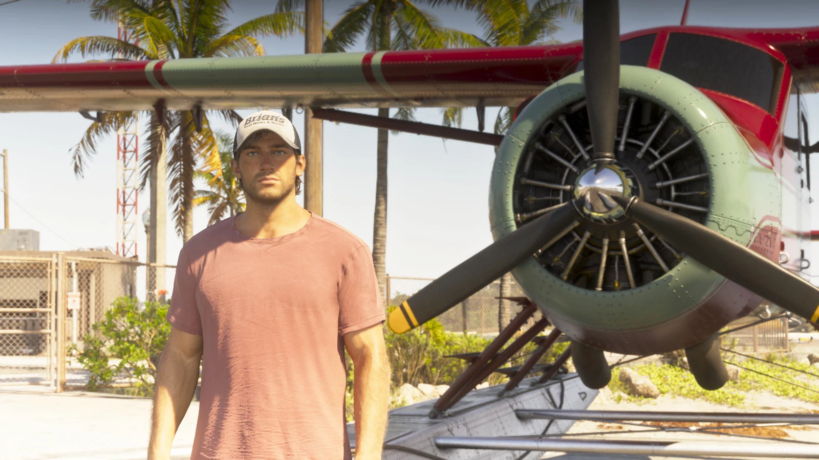
Image credit: Tyler C. / Rockstar Games, via PC Gamer’s 20 November flight report.
PC Gamer’s Tyler Colp reported a flight of about four minutes and eighteen seconds in a Mammoth Dodo, travelling from the southern archipelago towards the northern tip. It is a useful second observation because it names the aircraft and broad endpoints. It is not a road test, a fastest-aircraft record or a measurement of the map’s area.
The tempting move is to divide those two times and declare that flying is a precise multiple faster than driving. Resist it: the endpoints, path and vehicles are not a matched experiment. The valuable lesson is simpler. A relatively quick crossing can coexist with a substantial world because a vehicle moves quickly through a route, while exploring all the places beside it takes much longer.
What is the longest possible driving route in GTA 6?
If you can repeat roads, there is no finite longest route: drive another lap. For a meaningful record, define the challenge first. ‘The longest shortest road route between two accessible points’ asks for the farthest-separated pair in the road network. ‘The longest drive without repeating a road segment’ is a different challenge. ‘A full coastal tour’ needs a rule for inland detours and dead ends.
No verified road-network diameter or matched all-game longest-route dataset is supplied here. The Key Lento-to-Bonanza test is evidence for that particular trip, not proof that those endpoints maximise distance. The official poster suggests candidates for exploration, but it cannot tell us every access restriction, one-way rule, off-road possibility or route the released game’s GPS might select.
Three long road trips to plan from the original map
North–south sampler: Key Lento → Hamlet → the inland route towards Ambrosia → Bonanza. Compare your exact GPS route with the published crossing’s stated endpoints; do not assume identical roads.
Infrastructure tour: Mile Zero Air Station area → Key Lento → the VCIA approach → Port Gellhorn → Draper Island. Use legal, accessible approaches in your current save; a printed site is not a guarantee of unrestricted entry.
State sampler: Vice City → the eastern coastal settlements → the northern park approaches → Port Gellhorn → the Grassrivers side → the Keys. Treat these as suggested stops, not turn-by-turn navigation or a measured perimeter route.
For each trip, keep separate totals for kilometres, elapsed driving, stops and diversions. A route-planning screenshot is not an actual completed drive. An edited highlight reel can show the best moments without proving an elapsed time. If a future comparison publishes the raw run and the route, that is the evidence needed to replace a suggestion with a benchmark.
Released-game footage: GTA Series Videos’ Clear Skies walkthrough, published 20 November. This mission video shows traversal in context and contains spoilers. Its upload duration is not a map-crossing time.
Why twice the area does not mean twice the driving time
Imagine two similarly shaped square worlds. If one has twice the area, its edge is only √2—about 1.41—times as long. A diagonal crossing grows by the same factor if the road layout and speed stay comparable. This is an illustrative geometry example, not a calculation of GTA 6’s actual dimensions.
Real worlds are less tidy. A long island chain, a lake, a mountain pass or a dense grid can alter routes dramatically. Vehicles accelerate differently, intersections interrupt speed, and a crash can dominate a short run. That is why comparing area, direct distance, road distance and elapsed time in separate categories is far more useful than treating one as a proxy for all the others.
Area asks how much surface is inside a defined boundary.
Road length asks how much connected driving network exists.
Crossing distance asks how far one specific journey travels.
Crossing time adds the vehicle, traffic, rules and player performance.
Exploration time adds the reasons to stop, search and return.
GTA 6 map vs Cyberpunk 2077: geography versus vertical density
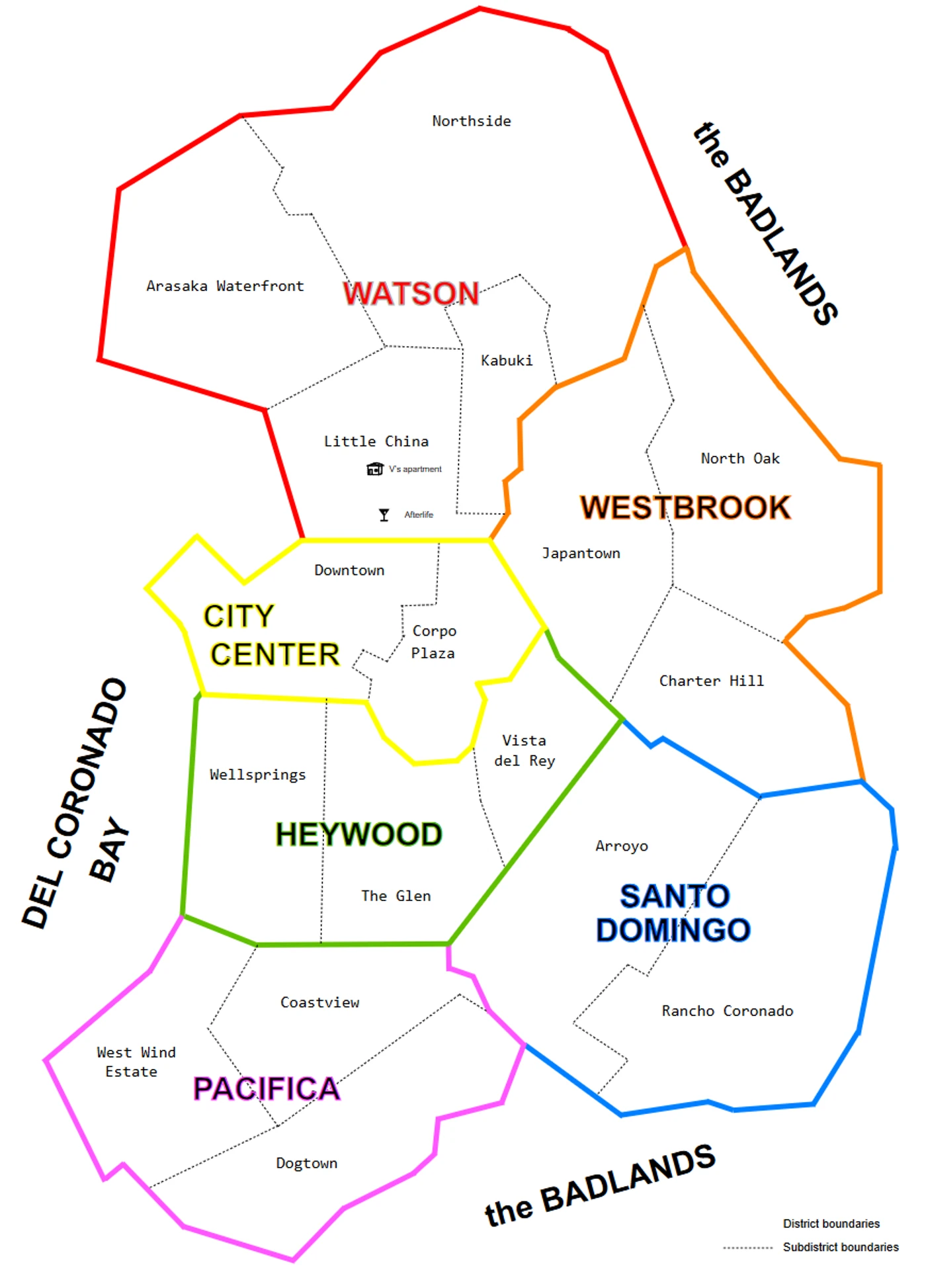
Archival community map: Pottero, Mapa Night City, CC BY-SA 4.0. Rasterised for web display; the original SVG is available here. The illustration is not at the same scale as Leonida and is not an official GTA comparison.
Night City’s dense core and the Badlands make Cyberpunk a useful comparison of urban concentration and outskirts. CD PROJEKT RED describes that contrast on its official game page. A top-down outline still misses a large part of the experience: stacked routes, elevated roads and spaces at different heights can matter more than a wider silhouette.
Compare the journeys you actually want from each game. For a city cruise, judge junctions, navigation clarity and how districts connect. For exploration, judge whether a building or street creates a reason to leave the vehicle. For scale, decide whether the Badlands and expansion areas are included. We are not assigning Cyberpunk a square-kilometre figure from an incompatible source just to force it into the GTA chart.
GTA 6 map vs Far Cry 3, 4, 5 and 6
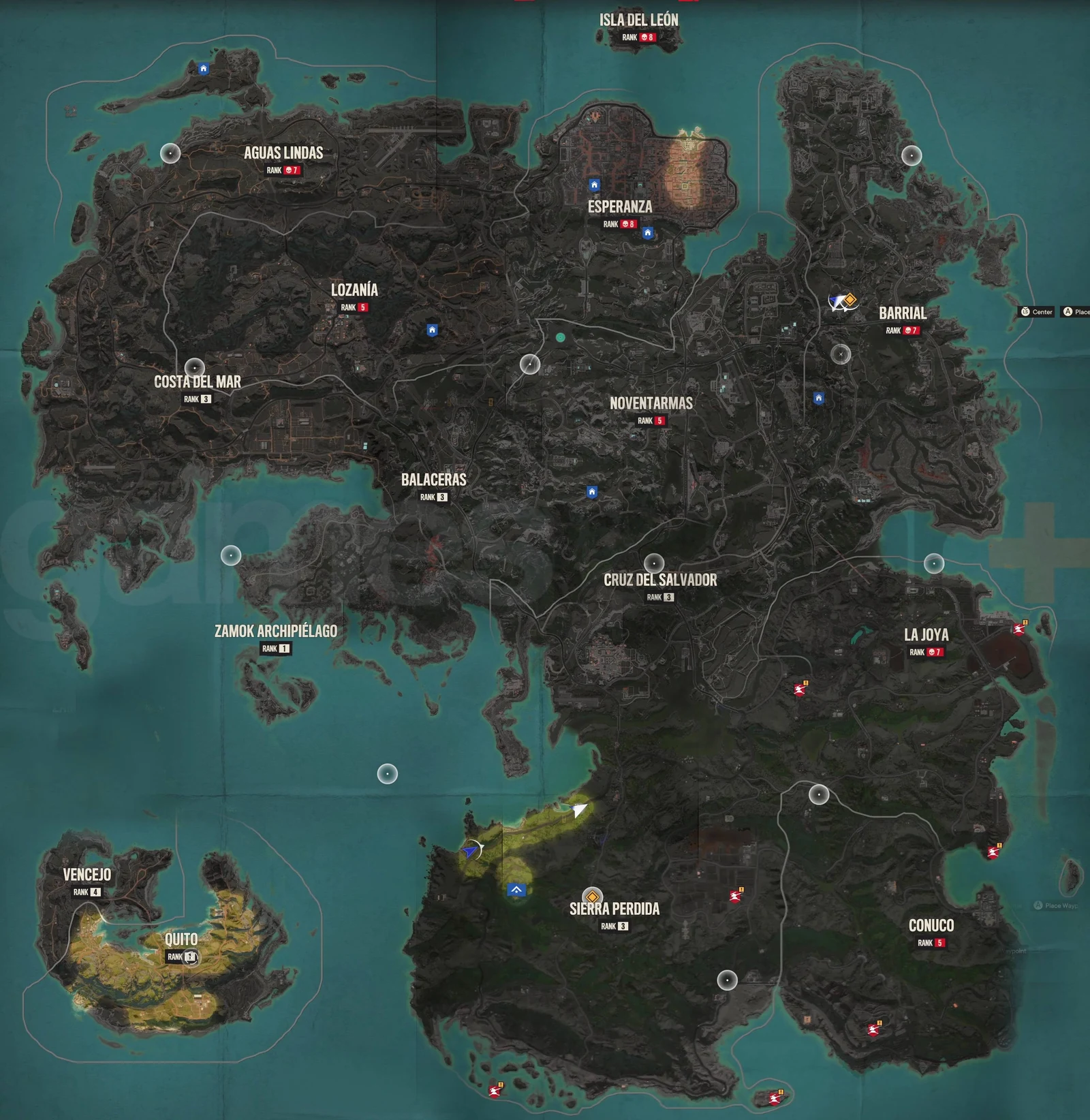
Archival image © Ubisoft, reproduced from GamesRadar’s Far Cry 6 map guide. Not at the same geographic scale as the GTA maps.
Far Cry is a useful rival because roads are only one part of how its spaces work. A landscape can be built around approaches, vantage points and contested locations rather than the flow of city traffic. That is a different design problem from making a street network support a long drive, a chase and everyday navigation.
Far Cry 3: compare the island-exploration rhythm and the reasons to leave the road, rather than only the footprint of the Rook Islands.
Far Cry 4: a mountain route through Kyrat makes elevation and indirect approaches central to the comparison. A straight line is an especially weak substitute for travel time.
Far Cry 5: Hope County’s rural setting offers a useful counterpoint to GTA’s urban driving. Ubisoft’s official page identifies the Montana setting and activities including fishing, hunting and wingsuit travel.
Far Cry 6: Yara’s island regions, towns and military infrastructure make the full route network more informative than a rectangular ocean-inclusive frame.
Sources for the historical comparison: Ubisoft’s Far Cry 3, Far Cry 4, Far Cry 5 and Far Cry 6 overviews, plus the Yara map guide. The gameplay-design observations here are GlitchBong’s analysis; this is not a claim that these games share one measured map-area standard.
Other open worlds: RDR2, Skyrim, The Witcher and Forza
Red Dead Redemption 2 is a useful test of pacing: comparing a horseback journey with a GTA highway run confuses traversal speed with world scale. Skyrim invites a different question—how much does a winding path, a climb or an interior add to a journey? In The Witcher 3, the comparison also needs to distinguish separate regions rather than pretending every destination lives inside one continuous driving map.
Forza Horizon 5 is useful when the question is specifically the pleasure of driving between destinations. GTA is also supporting a broader set of on-foot and story interactions. Assassin’s Creed Odyssey raises the water problem again: sailing space may be central to its experience, yet it is not interchangeable with walkable land. These are comparison lenses, not an unsourced numerical league table.
A fair multi-game test would therefore publish separate leaderboards for accessible land, urban footprint, road-network length, a defined crossing and exploration density. It might produce several different winners. That would tell readers more than a single gigantic silhouette that quietly changes the definition of ‘map’ from one game to the next.
Background references: CD PROJEKT RED’s Witcher 3 overview and the official Forza Horizon page’s Horizon 5 section. These are background game references, not post-launch GTA 6 measurements.
Post-release GTA 6 video gallery: watch the journey, not just the outline
All six embedded YouTube uploads in this article were checked against the original watch-page publication timestamps. They fall on 20–21 November in UTC, rather than relying on an aggregator’s rounded ‘two days ago’ label. They are released-game playthroughs, not official trailers or fan-made map reconstructions. Uploader titles, length and publication date do not independently prove a map-size or driving-time claim.
theRadBrad — Down to Earth / Part 4, 21 November. Commentary and story gameplay; use this for a street-level sense of moving between objectives, not as a timed survey.
MKIceAndFire — Part 6, no commentary, 20 November UTC. A longer gameplay reference with mission spoilers. The original page displays a 19 November Pacific timestamp, which converts to 20 November UTC.
GTA Series Videos — 100% walkthrough Part 3, 20 November. Extended play with substantial story spoilers. Its many hours of play are not a claim about how long one drive takes. If an embed is restricted in your region, use its direct YouTube link.
Why the map matters more than a bragging-rights number
The best open world gives you more than room to hold the accelerator. Its roads help you form a mental model. Its districts give places distinct identities. Its quieter stretches create contrast, and its useful destinations give you reasons to make a trip you could otherwise skip. A map earns its size when those parts work together.
That is the question to carry into Leonida: does a drive connect places you want to revisit, and does getting there create stories worth remembering? A ten-minute crossing can be a satisfying sprint through a much larger playground. A longer commute can be spectacular or tedious. The timer is evidence about a route; the experience is the reason people keep exploring.
Frequently asked questions about the GTA 6 map
Is there an official GTA 6 map in high resolution?
Yes. Rockstar’s GTA VI Media page supplies a printable Leonida map. The original JPEG is 5,775 × 7,900 pixels, inside a roughly 45 MB ZIP. This article provides a web display copy and links to the original download.
Can I explore the GTA 6 map in fullscreen here?
Yes. Use Fullscreen in the map widget, then zoom, pan, search or filter places. If native fullscreen is unavailable, an expanded view is used. Escape closes that expanded view. Without JavaScript, open the linked high-resolution image and use your browser’s zoom controls.
How big is the GTA 6 map compared with GTA 5?
Post-launch guides repeat an approximate twice-GTA-5 comparison. That does not establish a measured land-only area or a precise city-size ratio. This article keeps that reported comparison separate from historical community measurements and from the original poster’s dimensions.
How long does it take to drive across GTA 6?
A GamingBible report published 20 November describes roughly ten real-world minutes from Key Lento to Bonanza in an upgraded Stainer using the GPS’s quick route. It is one documented crossing, not a universal time or verified longest-route record.
Are the map’s markers all official GTA 6 collectibles?
No. The underlying poster is official; GlitchBong’s thirty numbered pins are approximate positions for named regions and landmarks. They are not a complete collectible, activity or mission database. The printed map’s original labels and road legend remain intact.
Are the GTA, Cyberpunk and Far Cry maps shown at the same scale?
No. Their illustrations are sized for reading. The historical GTA bar chart uses a stated community area dataset, while the other maps are visual references. A true shared-scale overlay would require a verified calibration and consistent boundary rules for each game.
Sources, dates and how this comparison can be updated
Current evidence: Rockstar’s launch-day map download; GTAside’s 20 November map report; SixStarsWanted’s 20 November name index; GamingBible’s 20 November driving report; PC Gamer’s 20 November flight report. The six gameplay uploads have direct links beside their embeds; their original publication timestamps and image credits are recorded in the media manifest.
Historical material is used only for comparison: original GTA map posters via GTABase, the community map-area method discussed by GTATracker, Pottero’s separately licensed Night City illustration, Ubisoft’s Yara map via GamesRadar and official background pages for the older games. Those sources are not presented as new GTA 6 gameplay. All game artwork remains the property of its owners; no general open licence is asserted.
Future updates should add a reproducible released-game area measurement, exact start-and-finish coordinates for longer road tests, raw uninterrupted footage and a matched-method comparison with older games. Until those exist, the unmeasured fields stay unmeasured. That leaves you with a map you can actually explore and comparisons you can check, instead of a very confident number nobody can reproduce.
More GTA coverage: GTA 6’s launch compared with Cyberpunk and the GTA 6 PC release discussion.